|
Westmoreland Heritage Trail |
one moment while we fetch a trail picture
|
|
|
Westmoreland Heritage Trail |
one moment while we fetch a trail picture
|
Trafford to Export Section— 9.4 gradual climbing miles alongside Turtle Ck passing through the suburbs of Pittsburgh.
Export to Delmont Section—3.5+ miles. Closed in 2025. Not yet built.
Delmont to Saltsburg Section—9.0 miles through rural, wooded Pennsylvania.
Westmoreland Heritage Trail
Location Between Delmont and Slickville, Westmoreland, Indiana County
Between Trafford and Export in Westmoreland County
Trailheads Trafford, Murrysville, Export, Delmont, Slickville, Sara Steele, Saltsburg
Length, Surface 29 miles planned, 9.0 miles paved, 5.9 miles crushed limestone
Character Uncrowded, wooded, shady, gentle grade
Usage restrictions No motorized vehicles, no horses
Amenities In Trafford, Murrysville, Export, Delmont, Slickville, Saltsburg
Driving time from Pittsburgh 30 to 50 minutes east
Trafford to Export—9.4 miles
The newest section of this trail, which opened in September 2017, runs along Turtle Ck from B-Y Park in Trafford to Export. The trail surface is crushed limestone. There are mile markers along the trail starting with zero in Saltsburg. These maybe moved once the next section is completed.
Although the trail starts near <<MPxx.X) <<B-Y park (MPxx.x>>, the trail group asks that you not park there. The parking lot is small and heavily used by fisherpersons and park users. Trail users should use marked spaces marked for bicyclist along the right side of the <<Parkside Creamery lot at Forbes and Seventh (MPX.X))>>. The trail entrance is a ramp from the fixit station at the right side of the parking lot. Turning left at the bottom of the ramp goes 0.3 miles past B-Y Park to the current (2025) end of the trail <<MPxx.x)>>. Turning right and crossing Forbes Rd goes <<8.8 >> miles to Export.
The trail is mostly in woods, with the creek on one side and a hill on the other side. <<At (MP20.8) miles >>, a sidepath goes to the creek with a swimming hole. We have seen kids jumping off the 20-foot railroad abutment into the creek, but we have no idea whether this is safe. Across th river from this spot is the ruins of a brick factory.
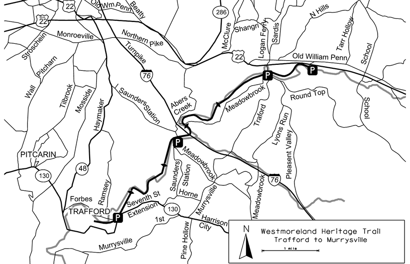
At <<MPXX.X>> the trail crosses Simpson Run. A little farther, on the trail passes by the Saunders Station Rd trailhead and then passes under the Pennsylvania Turnpike and almost immediately passes the obligatory sewer plant.
In the next couple of miles there are several busy road crossings. Use caution and be prepared to stop.
Shortly before Trafford Rd <<MPxx.x)>>the trail passes between a couple of industrial buildings. After Trafford Rd the trail returns to the woods until it bumps up against US22. Here the trail is just 10 to 15 feet below the buildings along the highway. At <<MPXX>X>> there is path to the Roberts Access Area with a visitor center and picnic tables.
From the Roberts Access Area a foot paths lead off to Duff Park, which has some hiking and mountain biking trails. Duff Park is an excellent destination to see and photograph wildflowers and is known for having one of the best displays of woodland spring blooming wildflowers in the area.
Past the Roberts Access Area, the trail is parallel to Route 22 and not very far from the road. At the Caterpillar rental yard the trail jogs right and passes between the yard and the creek.
In Export<<(MPxx.x) there is a railroad caboose>>. After crossing the road the trail jogs left alongside a parking lot, and ends at a handicap trailhead. Halfway down the parking lot is an unlabeled, brick, non-nondescript building that contains a small museum. Near by is a deli, pizza place and several restaurants.
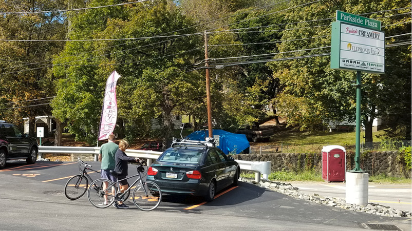
Designated bicycle parking in Parkside Plaza at Forbes Rd trailhead
Export to Delmont—3.5 miles
This section has not yet been developed and is closed. Getting the trail across US 22 is the major issue. The Westmoreland County Parks Department is working on it.
Delmont to Saltsburg—9.0 miles
The second completed segment starts just outside of Delmont at the Delmont/John Rangos Trailhead access. (MP8.5) This section has numerous benchs for a place to stop and admire the woods. The trail leaves the parking lot with an steepish 0.5 mile descent and at MP8.0 continues a gradual descent for 3.0 miles through woods. There are several road crossings in this section with very poor sight lines.
From MP7.2 to MP6.7 on the left is the slitted in/overflow area of the Beaver Run Reservoir, a municipal water supply lake. From MP6.7 to MP7.2 the lake is visible on both sides. The trail is on an embankment in this area, and the Municipal Authority has erected signs requesting trail users to stay on the trail and not approach the lake.
Near the <<???? Trailhead (MPXX.xx>> the trail begins a noticeable climb. Just after crossing SR819 (MP4.9), the Slickville Community park is on the left. Another 900 feet farther on, the fire department parking lot is used as a trailhead.
Opposite the fire department is the “Hollywood” sign for Slickville on top of a coal tailing heap. After leaving Slickville (MP5.0), the climbing ends and the trail begins a long steady descent to the Sara Steele trailhead (MP2.6). Turning left out of this parking lot there is 250 feet of loose gravel on Maple Lodge Rd. After crossing County Rd the trail is briefly alongside the paved road before continuing through shady woods, still descending, although not as steeply.
At MP2.5 the trail travels alongside open fields for a short distance. It reenters the woods at MP1.9, and at MP1.6 Loyalhanna Ck becomes visible downhill on the right. Off on the left, overgrown piles of coal tailings hint at the heritage of the region. Just past MP1.5 one of the original railroad mile markers still remains. At MP0.7 the trail crosses Loyalhanna Ck, passes under PA981 in a culvert, and then crosses the Conemaugh River—all within 1000 feet.
The trail ends at MP0.0 where it intersects with the West Penn Trail (page NE-205). A playground and parking area are on the right.
| Location | Between Delmont and Slickville, Westmoreland, Indiana County | ||
| Trailheads | Trafford, Murrysville, Export, Delmont, Slickville, Sara Steele, Saltsburg | ||
| Length, Surface | 29 miles planned, 9.0 miles paved, 5.9 miles crushed limestone | ||
| Character | Uncrowded, wooded, shady, gentle grade | ||
| Usage restrictions | No motorized vehicles, no horses | ||
| Amenities | In Trafford, Murrysville, Export, Delmont, Slickville, Saltsburg | ||
| Driving time from Pittsburgh | 0 hours 33 minutes |