|
Westmoreland Heritage Trail |
one moment while we fetch a trail picture
|
|
|
Westmoreland Heritage Trail |
one moment while we fetch a trail picture
|
Vicinity: Directions begin on I376 East about 14 miles east of Pittsburgh near the Monroeville, Turnpike, US22 exits. To reach this point from Pittsburgh, take the Parkway I376 East.
Forbes Rd/Parkside Creamery (western) trailhead: From the vicinity take exit 84A to follow the signs for PA48 South/Monroeville. Go about 3.5 miles and turn left/southeast on Broadway Blvd. Go 0.5 miles and turn left/east on Forbes Rd. Go 1.1 miles and just after crossing the trail turn left/south into the parking lot for the Parkside Creamery. Trail parking is on the right, away from the building. It is marked with orange paint.
Saunders Station trailhead: From the vicinity take exit 84A to follow the signs for PA48 South/Monroeville. Go about 0.8 miles and take the left fork on to Haymaker Rd. Go 0.5 miles and take the left fork on to Saunders Station Rd. Go 1.5 miles and just after crossing the trail turn right/west into trailhead parking.
Carson Street trailhead: From the vicinity take the left ramp to US22. Go 3.5 miles to just past Trafford Rd and take the right hand ramp to Reed Blvd. Go two blocks and turn right/south on Carson Av. Go one block and just before crossing the trail, the parking will be on the left.
Murrsyville Roberts Parcel trailhead: From the vicinity take the left ramp to US22. Go 4.3 miles, and just past the Fireplace and Patioplace Store, turn right/south into the Roberts trailhead and visitor center.
Murrsyville Roberts Parcel trailhead: From the vicinity take the left ramp to << US22. Go xx.x miles>>
Murrsyville Roberts Parcel trailhead: From the vicinity take the left ramp to<< US22. Go xx.x miles>>
Delmont/John Rangos trailhead: MP8.5 From the vicinity take the left ramp to US22. Go 10.6 miles, and at the intersection with PA66 and take the ramp to PA66 North and go about 1.0 miles. At Greensburg St, turn right/northeast and continue 0.4 miles while it changes its name to Freeport St. At the fork in the road, take the left fork to stay on Freeport St and go 0.1 miles. At this fork, take the right/northeast fork on to Athena Dr and go 0.9 miles. Just past the abutments for a former railroad bridge turn right/east on Athena Dr Ext and go 0.1 miles. At the signs for the trailhead turn right and up into the trailhead parking lot.
Slickville trailhead: From the vicinity take the left ramp to US22 and go 13.2 miles. At the intersection with PA819 turn left/north on PA819 and go 4.7 miles. Shortly after crossing the trail, turn right/east on Main St and go 0.1 miles to the Slickville Volunteer Fire Department parking lot/trailhead on the right. Exit the back of the parking lot to find the trail.

Warning lights at Story Rd Crossing
Sara Steele Access Area trailhead: From the vicinity take the left ramp to US22 and go 13.2 miles. At the intersection with PA819 turn left/north on PA819 and go 4.7 miles. Shortly after crossing the trail, turn right/east on Main St. Go 0.5 miles and at the bend take the slight right/east and continue on County Rd for 1.8 miles to Bartz Rd. The trailhead parking lot is visible on the right, but the entrance is on Maple Lodge Rd. Turn right/southeast on Batrz Rd and then immediately right/west into the lot. The trail here is along Maple Lodge Rd. To go east on the trail, turn left/north out of the parking lot and cross the intersection. To go west on the trail, turn right/south out of the parking lot, go 200 feet and turn right/west on the paved trail.
Saltsburg (eastern) trailhead: From the vicinity take the left ramp to US22 and follow US22 east. Go 2.4 miles and take the PA286 east exit. Go 6.3 miles and continue straight on PA380 East. Go 11.9 mies and continue straight on PA286. (Yes, back on PA286). Go 1.7 miles and at the “Y” intersection bear right to stay on PA286. Go 0.2 miles and at the bottom of the hill, turn left/east following PA286 across the bridge. After crossing the bridge into Saltsburg, immediately turn right/south on Water St. Go 6 or 8 blocks to the end, (depending how you count alleys), enter into the parking lot behind the playground. From the parking lot, exit on the leftmost trail. Within 500 feet the trail crosses a bridge and enters a culvert. This parking lot is also a middle trailhead for the West Penn Trail (page NE-205).
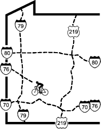
Westmoreland Heritage Trail - Access Points
Vicinity: Directions begin on I376 East about 14 miles east of Pittsburgh near the Monroeville, Turnpike, US22 exits. To reach this point from Pittsburgh, take the Parkway I376 East.
Forbes Rd/Parkside Creamery (western) trailhead: From the vicinity take exit 84A to follow the signs for PA48 South/Monroeville. Go about 3.5 miles and turn left/southeast on Broadway Blvd. Go 0.5 miles and turn left/east on Forbes Rd. Go 1.1 miles and just after crossing the trail turn left/south into the parking lot for the Parkside Creamery. Trail parking is on the right, away from the building. It is marked with orange paint.
Saunders Station trailhead: From the vicinity take exit 84A to follow the signs for PA48 South/Monroeville. Go about 0.8 miles and take the left fork on to Haymaker Rd. Go 0.5 miles and take the left fork on to Saunders Station Rd. Go 1.5 miles and just after crossing the trail turn right/west into trailhead parking.
Carson Street trailhead: From the vicinity take the left ramp to US22. Go 3.5 miles to just past Trafford Rd and take the right hand ramp to Reed Blvd. Go two blocks and turn right/south on Carson Av. Go one block and just before crossing the trail, the parking will be on the left.
Murrsyville Roberts Parcel trailhead: From the vicinity take the left ramp to US22. Go 4.3 miles, and just past the Fireplace and Patioplace Store, turn right/south into the Roberts trailhead and visitor center.
Murrsyville Roberts Parcel trailhead: From the vicinity take the left ramp to << US22. Go xx.x miles>>
Murrsyville Roberts Parcel trailhead: From the vicinity take the left ramp to<< US22. Go xx.x miles>>
Delmont/John Rangos trailhead: MP8.5 From the vicinity take the left ramp to US22. Go 10.6 miles, and at the intersection with PA66 and take the ramp to PA66 North and go about 1.0 miles. At Greensburg St, turn right/northeast and continue 0.4 miles while it changes its name to Freeport St. At the fork in the road, take the left fork to stay on Freeport St and go 0.1 miles. At this fork, take the right/northeast fork on to Athena Dr and go 0.9 miles. Just past the abutments for a former railroad bridge turn right/east on Athena Dr Ext and go 0.1 miles. At the signs for the trailhead turn right and up into the trailhead parking lot.
Slickville trailhead: From the vicinity take the left ramp to US22 and go 13.2 miles. At the intersection with PA819 turn left/north on PA819 and go 4.7 miles. Shortly after crossing the trail, turn right/east on Main St and go 0.1 miles to the Slickville Volunteer Fire Department parking lot/trailhead on the right. Exit the back of the parking lot to find the trail.
Warning lights at Story Rd Crossing
Sara Steele Access Area trailhead: From the vicinity take the left ramp to US22 and go 13.2 miles. At the intersection with PA819 turn left/north on PA819 and go 4.7 miles. Shortly after crossing the trail, turn right/east on Main St. Go 0.5 miles and at the bend take the slight right/east and continue on County Rd for 1.8 miles to Bartz Rd. The trailhead parking lot is visible on the right, but the entrance is on Maple Lodge Rd. Turn right/southeast on Batrz Rd and then immediately right/west into the lot. The trail here is along Maple Lodge Rd. To go east on the trail, turn left/north out of the parking lot and cross the intersection. To go west on the trail, turn right/south out of the parking lot, go 200 feet and turn right/west on the paved trail.
Saltsburg (eastern) trailhead: From the vicinity take the left ramp to US22 and follow US22 east. Go 2.4 miles and take the PA286 east exit. Go 6.3 miles and continue straight on PA380 East. Go 11.9 mies and continue straight on PA286. (Yes, back on PA286). Go 1.7 miles and at the “Y” intersection bear right to stay on PA286. Go 0.2 miles and at the bottom of the hill, turn left/east following PA286 across the bridge. After crossing the bridge into Saltsburg, immediately turn right/south on Water St. Go 6 or 8 blocks to the end, (depending how you count alleys), enter into the parking lot behind the playground. From the parking lot, exit on the leftmost trail. Within 500 feet the trail crosses a bridge and enters a culvert. This parking lot is also a middle trailhead for the West Penn Trail (page NE-205).